Upcoming reopening of the Swiss Passes

As spring arrives, the Swiss Passes are once again preparing to welcome mountain and adventure lovers. From the majestic peaks of the Alps to the picturesque valleys, the passes offer breathtaking views and a crucial route through the heart of the Alps.

Klausenpass Image by xuuxuu from Pixabay

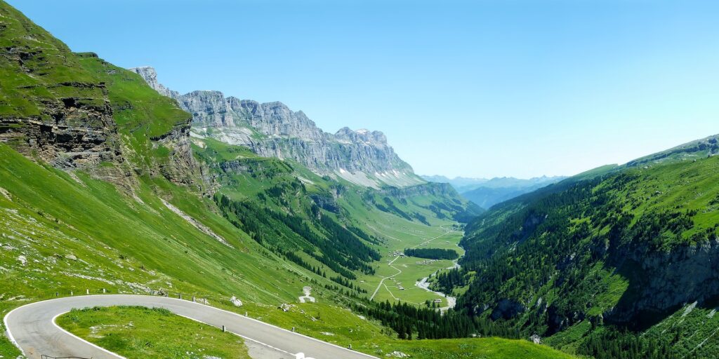
As the passes open, travelers will have the opportunity to explore the natural and historical wonders these routes offer. From ancient paths used by traders in the Middle Ages to modern roads connecting regions, Swiss passes are a bridge between past and present.

As the passes open to traffic and visitors, it is important to be mindful of road conditions and restrictions specific to each pass. Tourists can enjoy scenic restaurants, charging stations along the way and, of course, the thrill of crossing the Alps.

Below are the summer reopening dates of some of the Swiss passes:


Albula Pass

Bergün (GR) – La-Punt (GR), 22.7 km Altitude: 2312 m

In ancient times, there was a modest transit path along the Albula, also used by the Romans for trade. In 1695 the first tunnel was created, providing direct access to the Bergün Valley. The road was widened in 1864-1866 for postal stagecoaches. The opening of the Albula Railway in 1903 significantly reduced the importance of the pass.

The Albula Pass is scheduled to open on May 17.

Recent updates indicate that the road has some critical issues along some sections, being narrow and damaged. It is therefore not recommended to cross this pass with caravans or campers.

For those who need to cross this region, it is recommended to consider alternatives such as the Julier Pass or the Vereina shuttle train service (or the Flüela Pass during its opening period). It is important to note that the Albula shuttle train service is not currently in operation.

Transit is prohibited for heavy vehicles with trailers, maximum permitted weight 11 tons and a maximum height of 3.3 meters. Note that no charging stations are available along the road.

The Albula Pass remains closed during the winter months from December to May.

Bernina Pass

Pontresina (GR) – Poschiavo (GR), 38.5 km Altitude: 2328 m

The Bernina Pass, with a history dating back thousands of years and supported by Neolithic finds, was an important route between the Upper Engadine and Puschlav to the Veltlin. Although it never achieved the same importance as other Alpine passes, such as Spluga, it became significant when the Three Cantons conquered Valtellina in 1512. The French postal service between Lyon and Venice used it around 1550. The road has remained open year-round since 1965 and is also home to the famous Bernina Railway.

The Bernina Pass remains open year-round albeit with some restrictions

The Bernina Pass is open for all vehicles, but it is important to note that snow chains are mandatory as the road is currently snow-covered. The road is wide and easy to access while remaining subject to certain restrictions.

In terms of restrictions, transit with trailers is prohibited for heavy vehicles from November 16 to April 14. However, trailer transit is allowed when there is no snow on the roadway by presenting an official permit during this period.

As for electric vehicles, a charging station is available along the road, although it is to be considered a slow charging station.

Andermatt and Murten among world’s best tourist villages

Flüelapass Image by moerschy from Pixabay

Flüela Pass

Davos (GR) – Susch (GR), 27.9 km Altitude: 2383 m

The Flüela Pass is an Alpine pass in the canton of Graubünden, whose road was built in 1867 and is the shortest road route between the Rhine Valley and the Lower Engadine. The discovery of archaeological finds on the pass testifies to the ancient use of this route. The region became important in the 13th century with the settlement of the Walser families who, with their agriculture, traded their products across the pass, transporting goods as far as Tyrol and bringing back salt. With the opening of the Vereina rail tunnel in 1999, maintenance of the pass road in winter was discontinued. More info about the rail connections can be found here Autoverlad Vereina

Currently closed for all vehicles and scheduled to reopen on May 1, 2024.

The winter closure of the Flüela Pass is in effect, as usual, from January to May.

The Flüela Pass is also accessible for heavier vehicles, again subject to current restrictions.

No charging stations are currently available along the road for electric vehicles.

Livigno’s Forcola Pass

Livigno (Italy) – La Motta (GR), 19.3 km Altitude: 2315 m

The Livigno valley, initially isolated and settled late, became important in the 15th century for trade routes to Milan. Napoleon made it a free zone in 1805 to prevent depopulation. The Foscagno Pass became accessible in winter in the 1950s, while the Munt La Schera tunnel, opened in the 1960s, provided safe access.

Currently, the Forcola di Livigno remains closed for all vehicles, with a planned reopening on June 3, 2024.

Travel on this road with caravans or campers is not recommended. Heavy vehicles with trailers are also prohibited,

For those wishing to reach the Swiss National Park region from the Poschiavo Valley, via the Forcola di Livigno, it is important to keep in mind that the Munt La Schera tunnel is chargeable.

No charging stations are currently available along the road for electric vehicles.

Great St. Bernard Pass

Martigny (VS) – Aosta (Italy), 77 km Altitude: 2469 m

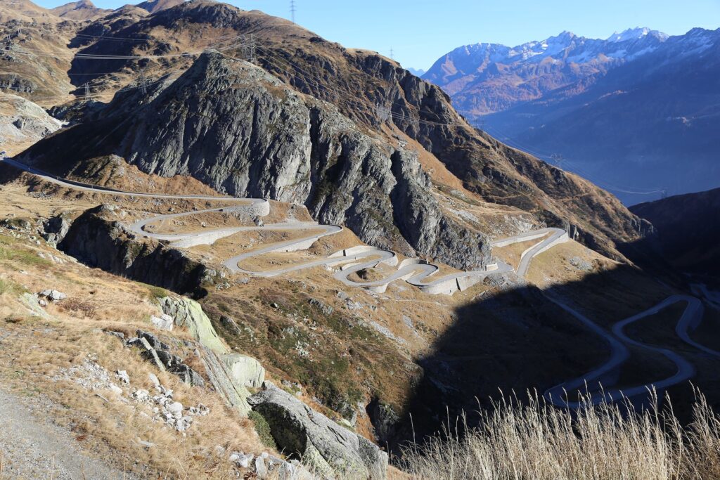
The Great St. Bernard Pass, at an imposing 2,469 meters high, is one of the best-known and most impressive mountain passes in Switzerland, linking the town of Martigny in the canton of Valais with Aosta in Italy, and offers breathtaking scenery on both sides.

The Great St. Bernard Pass is one of the oldest mountain passes in the Alps: since ancient times it has been used as an important communication route, both by the Romans and by medieval travelers and pilgrims. In the 19th century, major infrastructure developments, such as a carriage road in 1839 and a tunnel in 1964, were made, making the pass accessible year-round. Although its importance as a transit route has declined with the opening of more tunnels, the Great St. Bernard Pass remains a historical icon and a point of tourist interest.

The pass remains closed during the winter for all vehicles from October to June. At this time, no specific date is yet given about the summer reopening of the pass.

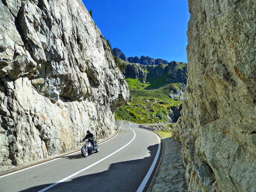
The Great St. Bernard requires caution when driving, especially in adverse weather conditions.

A fast charging station has recently been installed along the road for electric vehicles.

The Great St. Bernard Tunnel, opened on March 19, 1964, and 5798 m long was the first road tunnel opened to traffic through the barrier of the Alps and connects the Aosta Valley, Italy with the canton of Valais. The Tunnel is open year-round and charges a fee. More info can be found at: Le Tunnel du Grand-Saint-Bernard
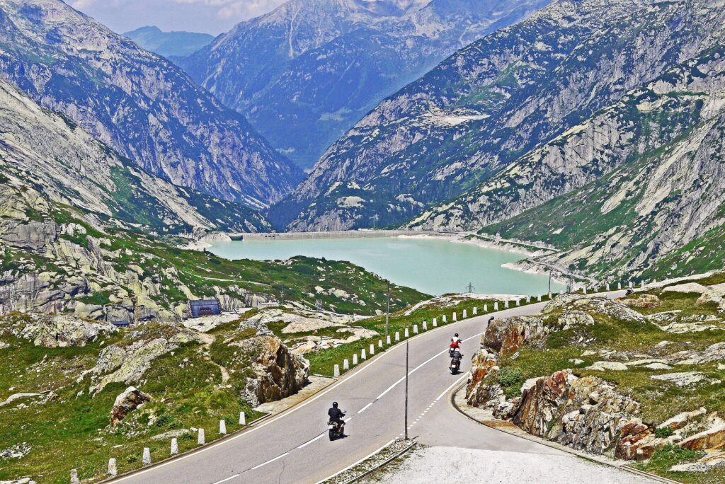
 

Grimselpass Image by Erich Westendarp from Pixabay

Grimsel Pass

Innertkirchen (BE) – Gletsch (VS), 32.5 km Altitude: 2164 m

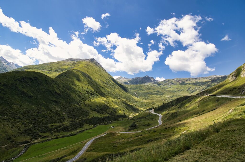
The Grimsel Pass, is one of the most important Alpine passes in Switzerland and is part of the separation of the Rhine basin and the Rhone basin. The pass road traverses a wild and barren mountain landscape characterized by granite rocks flanked by dams and hydroelectric power plants.

The pass is closed during the winter between the months of November and June for all vehicles except the Bernese section to Kunzentänneln. At the moment, no exact date is yet given about the summer reopening of the pass.

There is no charging station for electric vehicles on this road.


Julier Pass or Julier Pass also known as the Julier Pass

Savognin (GR) – Silvaplana (GR), 42 km Altitude: 2284 m

The Pass is one of the most widely used passes, providing stable communication between the towns of Sankt Moritz and Thusis. The history of the pass can be traced back to Roman times, but the present modern route dates back to the road built between 1820 and 1826.

The border between the Rhine and Danube catchment areas is located on the pass.

The Julier Pass remains open year-round, contributing to transportation and tourism in the region and offering an alternative to the adjacent Albula Pass.

During winter, trailers are banned from 16.11 to 14.04 for heavy vehicles, but may be allowed if there is no snow on the roadway with an official permit.

There is a slow charging station for electric vehicles on this road.

Klausen Pass

Altdorf (UR) – Linthal (GL), 46 km Altitude: 1948 m

The Klausen Pass, was not part of the network of trade routes through the Alps either during Roman times or in the Middle Ages and there was only a narrow path used almost exclusively for transporting livestock to the alpine pastures. Only after the opening of the Gotthard railroad did it become an attractive route for which a road was built in the late 1800s. From 1900, with the first stagecoach, it became a tourist route, and in 1922 postal bus service began.

During the winter months, the Klausen Pass remains closed from November to May. It is scheduled to reopen for summer on May 17, 2024.

Travel over this pass with caravans or campers is not recommended.

Towing prohibited for vehicles up to 2.3 m wide except for vehicles not exceeding 1.9 m wide and 4.5 m long.

There is a slow charging station for electric vehicles on this road.

During the summer months, the Klausen Pass Bus Line with the number 408 operates from June to October.

More than a century ago, the first stagecoach crossed the Klausen Pass, with the journey taking a day and a half. Today, thanks to modern transportation, the regular bus route from Altdorf across the Pass to Linthal takes approximately two hours. It is important to note that tickets for public transportation, such as the Halbtax and GA, are valid on the Klausen Pass Line.

Lukmanier Pass

Disentis/Mustér (GR) – Olivone (TI), 48 km Altitude: 1914 m

The Lukmanier Pass, used since early medieval times as a route between the Po Valley and the Rhine Valley, as well as a religious route between shrines and monasteries, became one of the busiest passages in Europe. Guarded by the ancient abbey of Disentis (or Mustér in Romansh), originally affiliated with the rule of St. Columba, the pass saw the creation of hospices, forts and churches along its route.

From the 13th century, the pass gradually lost importance in favor of the Gotthard Pass. The construction of the road across the pass dates back to 1876.

The Lukmanier Pass has been open year-round since 2000 although it may be temporarily inaccessible at night or during the day in case of adverse weather conditions

Some restrictions are in place in case of snow, with trailers prohibited except 4×4 vehicles.

There are no charging stations for electric vehicles on this route.

Maloja Pass

Chiavenna (I) – Silvaplana (GR), 32 km Altitude: 1815 m

The Maloja Pass was already of major importance in Roman times as an access route to the Julier Pass and to the Engadine, later connecting to the Tyrol. Over the years, various improvements were made, and in 1957 it underwent significant modernization. However, with the construction of the San Bernardino road tunnels in 1967 and the Gotthard in 1980, the Maloja Pass lost its importance as a freight transit route.

The pass remains open for all vehicles year-round.

Traffic is allowed for semi-trailers from 15.04 to 15.11.

There are no charging stations for electric vehicles on this route.

Nufenen Pass

Ulrichen (VS) – Airolo (TI), 38 km Altitude: 2478 m

The Nufenen Pass is the second highest Alpine pass in Switzerland after Umbrail. Construction of the pass road took place between 1965 and 1969, when it was opened to motorized traffic. This route has been extremely important for traffic between Ticino and Valais, mentioned in numerous historical publications since the 12th century. Nearby are Lake Gries and the Corno Gries Hut, the Corno Pass with its eponymous pond, and the westernmost point in Canton Ticino. The Nufenen Pass area is also home to the headwaters of the Ticino and Ägene rivers.

During the winter months, the Pass remains closed from November to June. On the Ticino side, the road also remains open during the winter months up to the All’acqua location. At the moment there is no exact date given about the summer reopening of the pass.

There are no charging stations for electric vehicles along the route.

Oberalppass Image by Monika from Pixabay

Oberalp Pass

Andermatt (UR) – Sedrun (GR), 23.6 km Altitude 2044 m

In the past, the Oberalp Pass was not of great importance, and the carriage road was built between 1852 and 1863. The five-horse stagecoach made tourism flourish and in 1921 in turn was replaced by the postal bus. In 1926, the Furka-Oberalp Railway (now the Matterhorn-Gotthard Railway) cog railway was opened with steam trains replaced in 1942, by electric trains. The road (summer) and the railway (year-round) are of great importance for tourism in the Urseren Valley and Surselva.

The pass is closed for all vehicles during the winter months from December to April. It is scheduled to reopen on April 26, 2024.

Not recommended to travel the pass with caravans or campers.

There are no charging stations for electric vehicles along the route.

San Bernardino Pass

Hinterrhein (GR) – San Bernardino (GR), 17 km Altitude: 2065 m

The San Bernardino Pass is a mountain pass in the canton of Graubünden, connecting the Rheinwald valleys to the north and the Misox valleys to the south. At the top of the pass, the European watershed and the language boundary between German and Italian pass.

The pass was given its name in the 15th century, when a chapel dedicated to St. Bernardine of Siena was built, replacing the earlier Mons avium or Vogelberg.

The history of the pass dates back to Roman times, which used the easy and topographically simple passage. In the 15th century, as transit traffic developed, the route was widened, and the road across the Viamala was built after 1473. At the beginning of the 19th century, one of the first modern Alpine roads was built over this pass, desired by the Canton of Graubünden and also financed by the Kingdom of Sardinia, which allowed traffic from Piedmont and the port of Genoa to reach the Rhine Valley without passing through roads controlled by Austria.

With the opening of the San Bernardino Tunnel (A13) in 1967, Misox is again connected year-round to the rest of Canton Graubünden.

During the winter months from November to May, the pass remains closed to all vehicles. It is scheduled to reopen on May 17, 2024.

There are no charging stations for electric vehicles on this route.

Gotthardpass Image by Beatrice Schmuki from Pixabay

Gotthard Pass

Andermatt (UR) – Airolo (TI), 26.1 km Altitude: 2108 m

The Gotthard Pass, mentioned in the 13th century in the Annales Stradenses, was a crucial point for travelers heading to Rome or the Holy Land as well as for trade and communication between different cultural and linguistic regions. In 1595, a stone bridge was built in the Schöllenen Gorge. It was not until 1708, under the direction of Pietro Morettini, that a tunnel was built to facilitate access to the bridge. In the 19th century, with the construction of a carriage road and new bridges, travel became easier. The construction of the railway and the Gotthard rail tunnel significantly reduced travel time in the latter half of the 19th century.

The Gotthard Pass is closed in winter from November to May to all vehicles. It is scheduled to reopen in mid-May 2024.

Semi-trailers and trucks (with the exception of military vehicles) are prohibited on this road.

There are currently no charging stations along the road for electric vehicles.

Sanetsch Pass

Sion (VS) – Sanetsch Lake (VS), 33.5 km Altitude: 2252 m

The Sanetsch Pass is a scenic and seldom-visited pass that starts among the vineyards of the Rhone Valley, passes through a forest and a series of hairpin bends leading to pastures and the summit at 2252 m above sea level, near the Tsanfleuron glacier. The tour ends at Sanetsch Lake, from which it is possible to descend to Gsteig via a gondola. The pass is home to an artificial lake created for hydroelectric purposes and a rock climbing area.

During the winter months the pass remains closed from October to June. There is currently no exact date given about the summer reopening of the pass.

There are no charging stations for electric vehicles on this route.

Simplon Pass

Brig (VS) – Iselle (Italy), 45 km Altitude: 2005 m

The pass is considered the border point between the Pennine Alps to the west and the Lepontine Alps to the east. Until the early Middle Ages, little is known about the use of the Simplon pass. Political and economic transformations in the late 12th century made the Pass a major transit route between important European economic areas. After 1320, trade flows shifted to the Gotthard and Graubünden passes so the Simplon lost its importance. In 1800, Napoleon built a road that opened in 1805. In 1906 with the opening of the Simplon tunnel, at that time the longest rail tunnel in the world, the pass suffered a significant decline. From 1957 improvements were made to the road through the construction of numerous bridges and viaducts that made the pass pass passable even in winter, which was followed by an increase in heavy traffic. The Simplon is a popular destination for walking and hiking.

The Simplon pass is open year-round, and in the event of a temporary closure of the pass, a Simplon shuttle train service is available to transport vehicles on special wagons between Brig and Iselle.

During the winter months, winter tires and/or snow chains are mandatory.

Transit over this pass with trailers and caravans is prohibited.

A slow charging station for electric vehicles is available on the road.

Passo dello Spluga

Splügen (GR) — Chiavenna (Italia), 39 km Altitudine: 2113 m

Il Passo dello Spluga, connette l’alta valle Spluga con la valle del Reno superiore (Rheinwald). Oltre alla sua importanza storica e logistica, il passo ha anche rilevanza geologica, poiché separa la falda Tambò a ovest dalla falda Suretta a est.

Il Passo dello Spluga divide le Alpi Lepontine dalle Alpi Retiche e, secondo la tradizionale bipartizione delle Alpi in uso negli altri Paesi della catena alpina, ripresa dalla classificazione SOIUSA, divide le Alpi Occidentali dalle Alpi Orientali.

Il suo percorso è caratterizzato da 72 tornanti tra Chiavenna e Splügen. Alcuni ritrovamenti di insediamenti preistorici dell’età della pietra fanno supporre un uso del passo ben antecedente a quello che i Romani.

Il traffico di transito rappresentava una parte vitale dell’economia locale. Tra il 1818 e il 1823, fu realizzata una strada carrozzabile e postale che incrementò notevolmente il traffico di merci e persone internazionale attraverso lo Spluga, raggiungendo il suo picco nella metà del XIX secolo. Tuttavia, l’avvento delle ferrovie alpine cominciò a ridurre il traffico di transito sullo Spluga, e l’apertura della ferrovia del Gottardo nel 1882 praticamente interruppe il flusso di transito nei Grigioni, provocando una vasta emigrazione.

Il passo dello Spluga rimane normalmente chiuso nei mesi invernali tra Novembre e Marzo. La riapertura estiva è prevista 2 maggio 2024.

There is no charging station for electric vehicles on this road.

Sustenpass Image by xuuxuu from Pixabay

Susten Pass

Innertkirchen (BE) – Wassen (UR), 46 km Altitude: 2234 m

The Susten Pass has a history dating back to antiquity, with archaeological evidence of prehistoric settlements indicating its importance as early as that time. This pass is never as important as other trade routes. The Swiss recognized its strategic importance in the early 1800s after Napoleon blocked the trade route through the Simplon Pass. Bernese and Urans joined forces to quickly turn the old Susten mule trail into a carriage road. In 1938, the federal and cantonal authorities of Bern and Uri decided to build a modern road over the pass, both for transportation reasons and for national defense needs in preparation for World War II. On September 7, 1946, the road was opened, and today the Susten Pass is one of the most popular passes in Switzerland.

The Susten Pass normally remains closed during the winter months between November and June. It is scheduled to reopen in summer June 14, 2024.

There are currently no charging stations along the road for electric vehicles.

Umbrail Pass or Giogo di Santa Maria

Santa Maria (GR) – Bormio (I), 32 km Altitude: 2501 m

The Umbrail Pass is located in the western Rhaetian Alps and connects the canton of Grisons with the upper Veltlin. It is the highest carriageable pass in Switzerland, opened in 1901.

The passage across the Umbrail between Santa Maria and Bormio existed as early as the Middle Ages and served as an important transit path in Bormio’s trade with the north and was of particular interest to Venice, as it was a direct extension of the Venetian routes across the Gavia and Mortirolo to the north. The importance of the Umbrail Pass ended with the onset of the modern age, and today this fully paved pass is an ideal destination for cyclists and motorcyclists, thanks to the attractive environment and landscape and the low vehicular traffic. The pass offers stunning panoramic views of the surrounding countryside and is a popular destination for tourists and nature lovers.

The Umbrail Pass is subject to winter closure from November to May. It is scheduled to reopen in summer between late May and early June 2024.

Traveling over this pass with caravans or campers is not recommended. Towing for heavy vehicles is also prohibited.

There are currently no charging stations along the road for electric vehicles.

BANNER K16
BANNER K16