


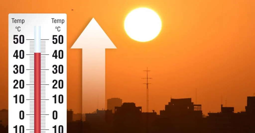
Heatwave: hot weather alert in Europe
The heat wave has reached all of Switzerland. A further slight increase in temperatures is expected south of the Alps in the coming days, which is why the heatwave alert level has been raised to 4. Several new temperature records have been set in Europe.
Over central and western Europe there is a vast anticyclonic promontory originating directly from the African continent that has been given the name Apocalypse4800, (4800 stands for the exceptional altitude that the thermal zero is reaching, that is, the altitude at which 0°C is recorded, never so high).On the summit of Mont Blanc (4809 meters high) the ice is melting; since it is the highest peak in the Alps, it goes without saying that all glaciers in the Alps are undergoing massive melting.
Across Europe, record temperatures are being recorded: Portugal has reached 47°C, several parts of France have recorded the hottest days on record with temperatures over 40°C, the United Kingdom is about to experience the worst heat wave in its climatic history, and the city of London has reached 40°C.
In the second part of the week, the heat will be more intense and persistent also on the Italian peninsula with values close to 40°C over several areas of the Po Valley, in cities such as Alessandria, Lodi, Cremona, Mantua, Bologna and also in the Centre-South, between Florence and Terni, as well as over Foggiano and the Sardinian hinterland between Sassari, Oristano and Cagliari.
Peaks of up to 30-32°C will also be possible at 1000-1300m above sea level, even towards 25-27°C at 1600-1800m with zero temperatures remaining consistently above 4000m at least until July 25 over the Alps and Apennines.
Switzerland to a national drought prevention and warning system
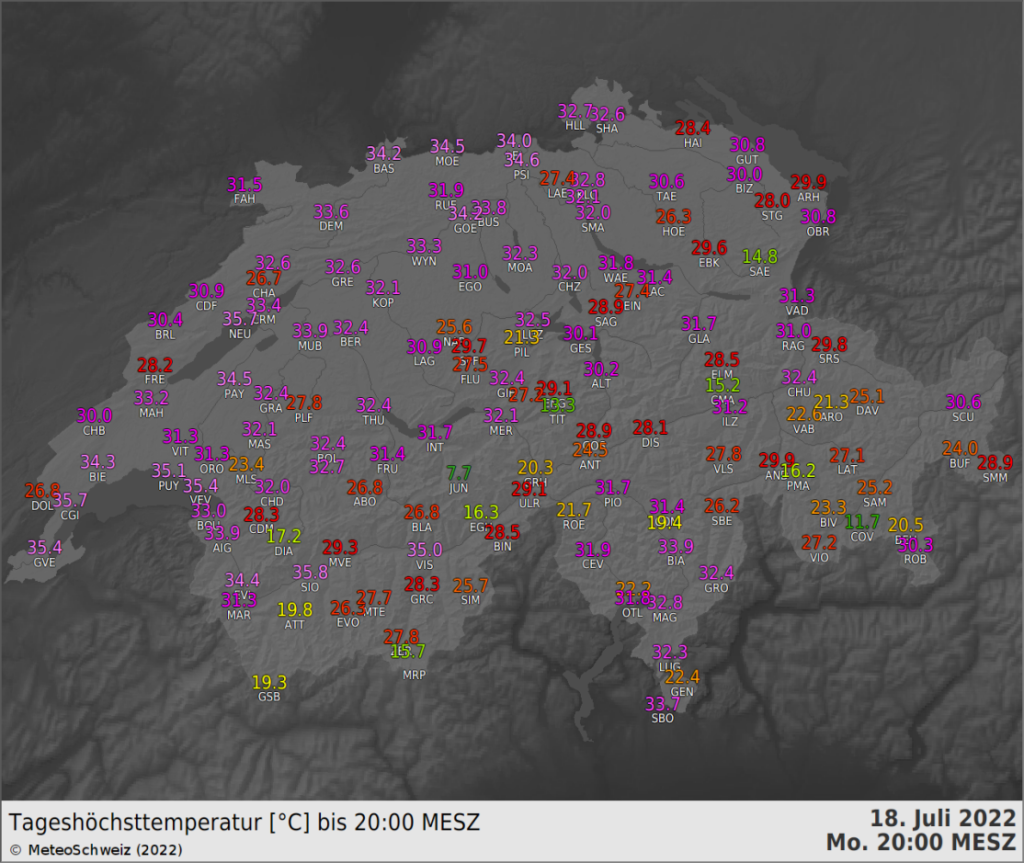
Monday’s maximum temperatures
South of the Alps, the level 3 heatwave alert has been active since last week. On Monday, western and northwestern Switzerland was also affected by the heat wave. Highs ranging from 33 to nearly 36 degrees were recorded in the alerted areas. In the lowlands of the other regions, for which the level 3 heatwave alert has only been in effect since Tuesday, highs were mostly between 30 and 34 degrees.
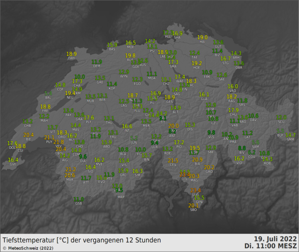
Very high minimums in the South due to overnight cloudiness
As has been the case in recent days, a layer of low cloudiness formed south of the Alps during last night that slowed the temperature drop.
Responsible for this cloudy layer was the wetter and less warm air that flowed in from the southeast between last Saturday and Sunday, still present over our regions and clearly visible in the vertical temperature profile measured by the Novara radiosonde at 2 a.m. last night.
The minimum temperature recorded in Locarno and Lugano was 23.4 °C, a value that is still not among the ten highest since the beginning of the measurements.
Cooler summers in the city thanks to appropriate building materials
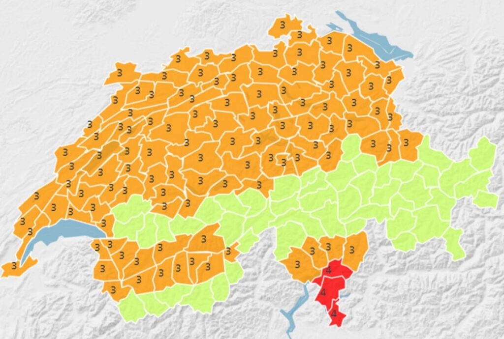
Level 4 alert in the south
A very warm and humid air mass remains south of the Alps. Therefore, temperatures will rise slightly in the coming days, especially in the minimum values, which will be between 20 and 21 °C in lowland areas and on valley floors, between 23 and 25 °C in hilly and urban areas. Afternoon highs will be between 33 and 36 °C. The thunderstorms expected north of the Alps and in the Alps between this evening and tomorrow evening will have no particular effect on temperatures at low altitudes in south-central Ticino, which will therefore remain very high. The mentioned temperature values justify raising the alert level from 3 to 4 for the southernmost Ticino regions starting tomorrow, while the level 3 alert remains active for the remaining regions. The alerts are currently scheduled to end on Monday evening, July 25, but based on the latest data it is possible that they will be extended.
Temperatures forecast for the northern part of the Alps have decreased slightly. The latest model data show a somewhat sharper cooling for Thursday than was still forecast yesterday. This means that north of the Alps the threshold values for the heatwave alert will be reached only locally.
Climate change and consequences
Record heat in some regions of France and the United Kingdom
In France and England, the heat wave has reached its peak. Ahead of the low-pressure area over the Atlantic, very warm air of subtropical origin was carried northward. At Herstmonceux in southern England, last night’s radiosounding recorded 23.8 °C at the isobaric altitude of 850 hPa (about 1,500 meters above sea level).
Temperature records have been broken in the past 24 hours at many locations, as Meteofrance and Metoffice report on Twitter . In France, highs of more than 40 °C have been reached in some locations, with Biscarosse (southwest of Bordeaux) even reaching 42.6 °C yesterday. The previous record of 41.7 °C dates back only to the heat wave a month ago (data from 1965).
With a daily maximum of 40.2 °C measured at London Heathrow, a temperature above 40 °C was recorded for the first time in the British Isles.

MeteoSwiss and the Federal Office of Public Health (FOPH) shed some light on common beliefs and myths related to high summer temperatures.
“Heat at noon is the most dangerous and should be avoided.”
MeteoSwiss: The myth of “hot at noon” persists, but usually temperatures on a hot summer day peak between 4 p.m. and 5 p.m. (local time). Although the highest point in the Sun’s apparent trajectory is reached at noon, the air temperature continues to rise in the afternoon. The following also applies: when temperatures are high, direct light from the Sun should be avoided as much as possible. Therefore, it is better to stay in the shade, possibly cool, both at noon and in the afternoon hours.
“Heatwave warnings are not necessary. It is still summer, it is normal to be hot.”
MeteoSwiss: Because of the varied negative impacts on health, the agricultural sector and the environment, the federal government is warning the public about periods of particularly intense heat. This raises awareness about the dangers associated with heat, which has a direct effect on our health and is one of the deadliest natural hazards. In the summer of 2021, MeteoSwiss revised the heatwave warning concept and adapted it to the results of the latest scientific research. The new heatwave alert concept now takes into account both high nighttime temperatures and short periods of intense heat, which can still cause severe stress to the human body.
Heatwave alerts
MeteoSwiss issues heatwave alerts for three levels of danger, levels 2, 3 and 4.
- If the average daily temperature remains at values that do not have a significant impact on health, we are at level 1 (no or weak danger).
- If the average daily temperature reaches 25 degrees or more for at least one day, circulatory problems and discomfort may already occur (danger level 2, moderate danger).
- If the 25-degree threshold is reached or exceeded for at least three days, the danger to health increases further and we are at danger level 3 (marked danger).
- From an average daily temperature of at least 27 degrees for at least three consecutive days, we reach danger level 4 (strong danger): at this point there is a strong impact on human health.
“Feeling sluggish and tired is no cause for alarm; it is normal to have less energy when it is hot.”
FOPH: Not true, tiredness and weakness can sometimes be signs of heat-related stress. Other symptoms include:
- Elevated body temperature
- Increased heart rate
- Headaches
- Muscle cramps
- Dry mouth
- Confusion, dizziness, loss of consciousness
- Nausea, vomiting, diarrhea
If these symptoms occur, immediate action should be taken: have the affected person lie down and cool the body with wet towels. If the person is conscious, give him or her cool water to drink. If these measures are unsuccessful, call a doctor immediately.
“Heat waves and their consequences will increase.”
MeteoSwiss: That’s right. Due to climate change, extreme weather events will increase significantly, including, of course, heat waves. Since measurements began, summer temperatures in Switzerland have already increased by as much as 2°C. This trend will persist in the future as well: heatwave periods as well as tropical nights will become not only more frequent but also more extreme. In Zurich, in the period between 1981 and 2010, there were about 5 days with temperatures above 30 °C per year (so-called tropical days). This number will rise to 14-21 days by 2060 without consistent and decisive climate protection measures. More information regarding these estimates is available in the CH2018 climate scenarios .

“My diet does not particularly affect my health during hot days.”
FOPH: It doesn’t. It is especially important to drink enough during hot days. It is recommended to drink at least 1.5 liters a day – while limiting the consumption of sugary, caffeinated or alcoholic beverages. Fruits and vegetables, which are rich in water, also contribute to fluid intake. Cold, lightly salted meals are easier to digest and help compensate for salt loss through sweating.
Source: MeteoSwiss